Former Chairs of JURSE
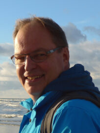
CARSTEN JÜRGENS
Ruhr-University Bochum (RUB)
Prof. Dr. Carsten Juergens, born 1961, is full professor for remote sensing in the geomatics group within the geography department at Ruhr-University in Bochum (RUB), Germany.
He graduated with a Diploma from Trier University in 1989. He reached his Ph.D. degree in 1992 from the same university, and then moved to University of Regensburg for an assistant professorship. In 1999 he finished his habilitation.
In 2004 he was appointed full professor for remote sensing at Ruhr University Bochum, Germany.
In 1997 he initiated a national workshop under the umbrella of DGPF titled “Remote sensing in urban areas“. After this successful national event and due to rapidly increasing urbanization on the one hand and increasing number of VHR satellite data, Carsten Jürgens came up with the idea of organizing an international symposuim on this topic, He was convinced that this topic needs a special conference format to discuss with international colleagues. Counting the national workshop as number one event, consequently the 2nd International Symposium on Remote Sensing of Urban and Suburban Areas was held 2001 in Regensburg. Regarding the relevance ot the topic, around 130 international participants convened in Regensburg. Due to the great success, his colleague and friend Derya Maktav hosted the 3rd International Symposium on Remote Sensing of Urban and Suburban Areas in Istanbul in 2002 to continue the discussons. An even greater success with a larger number of participants led to the decision to host the 4th International Symposium on Remote Sensing of Urban and Suburban Areas in Regensburg in 2003 again.
From 2005 onwards two urban remote sensing conferences were fused together as two tracks oft he newly established Joint Urban Remote Sensing Event (JURSE) for the benefit of the participants. The former International Symposium on Remote Sensing of Urban and Suburban Areas was renamed to be the track „Urban Remote Sensing (URS) and the former Remote sensing and data fusion over urban areas (URBAN). JURSE conferences with the two tracks URS and URBAN are held on a regular biannual cycle.
He has organized and was a member of the organizing committees of further other numerous national and international symposia.
Since 2003 he initiated the new EARSeL working group “Urban Remote Sensing” and is its chairman since then. From 2000-2004 he was Co-Chairman of working group 4 “Human Settlements and Impact Analysis” of ISPRS Commission VII (Resource and Environmental Monitoring). He was the Co-Chair of ISPRS-WG VIII/1 Human Settlements and Urban Impacts (2004-2008) of Commission VIII (Remote Sensing Applications and Policies). After that he was Co-Chairman of Working Group 8 “Land” of ISPRS-Commission VIII (Remote Sensing Applications and Policies).
He was guest editor of four Special Issues of the International Journal of Remote Sensing and the IEEE Transactions on Geoscience and Remote Sensing.
From 2003-2014 he served as editor of the German journal „Photogrammetrie – Fernerkundung – Geoinformation“ (PFG), and in addition to that he reviewed numerous articles for many national and international Journals
His expertise areas are: Urban Remote Sensing, Digital image processing, Photogrammetry and GIS.
More info on https://www.geographie.ruhr-uni-bochum.de/forschung/geomatik/mitarbeiter-innen/juergens/
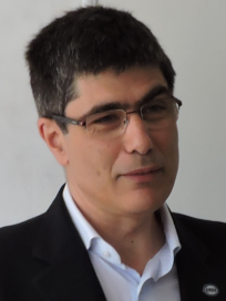
PAOLO GAMBA
University of Pavia
Paolo Gamba is Professor at the University of Pavia, Italy, where he leads the Telecommunications and Remote Sensing Laboratory. He received the Laurea degree in Electronic Engineering “cum laude” from the University of Pavia, Italy, in 1989, and the Ph.D. in Electronic Engineering from the same University in 1993.
He served as Editor-in-Chief of the IEEE Geoscience and Remote Sensing Letters from 2009 to 2013, and as Chair of the Data Fusion Committee of the IEEE Geoscience and Remote Sensing Society (GRSS) from October 2005 to May 2009. He has been elected in the GRSS AdCom since 2014, and he is currently the GRSS President.
He has been the organizer and Technical Chair of the biennial GRSS/ISPRS Joint Workshops on “Remote Sensing and Data Fusion over Urban Areas” from 2001 to 2015. He also served as Technical Co-Chair of the 2010 and 2015 IGARSS conferences, in Honolulu (Hawaii), and Milan (Italy), respectively.
He has been invited to give keynote lectures and tutorials in several occasions about urban remote sensing, data fusion, EO data for physical exposure and risk management. He published more than 140 papers in international peer-review journals and presented nearly 300 research works in workshops and conferences.
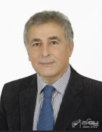
DERYA MAKTAV
Istanbul Technical University (ITU)
Prof.Dr. Derya Maktav, born 1951, is a full professor in the Department of the Geomatics Engineering at the Istanbul Technical University (ITU).
He graduated with a B.Sc. degree from the Department of Geomatics Engineering ITU in 1975. In 1976 he was awarded a certificate in Photogrammetry from University College London (UCL), Department of Photogrammetry and Surveying. In 1979 he was awarded an M.Sc. from Karlsruhe Technical University, Faculty of Civil Engineering and Surveying Germany and was a Ph.D. visiting scientist at the same university between 1983-84. In 1985 he received his Ph.D degree from the Geomatics Engineering Department at ITU. In 1985 he gained a certificate from Purdue University, Laboratory for Applications of Remote Sensing (LARS), USA, on the course ‘Digital Analysis of Thematic Mapper Data’.
At ITU he was appointed associate professor (1985) and full professor (1986) in the Remote Sensing Division. In 1993 he was a visiting fellow at the Department of Land Information, Centre of Remote Sensing, Royal Melbourne Institute of Technology (RMIT) in Australia. He was the Chair of ISPRS-WG VIII/1 Human Settlements and Urban Impacts and representative of ISPRS (GeoUnions Joint Science Program Team-Cities and Megacities) (2004-2008), Co-chair of the European Association of Remote Sensing Laboratories (EARSeL)-Special Interest Group: Urban Remote Sensing (2005-…), National representative of Urban Data Management Society (UDMS).
He was elected as a council member of the EARSeL in 2007. He has served as a member of the New York Academy of Sciences, EARSeL, Turkish National Associaton of Remote Sensing and Photogrammetry (TUFUAB), Turkish Chamber of Mapping and Cadastre (TMMOB-HKMO), and the German Association for Photogrammetry and Remote Sensing (DGPF).
He was guest editor for Special Issues of the International Journal of Remote Sensing, IEEE Selected Topics in Applied Earth Observations, Journal of the Indian Society of Remote Sensing, ASPRS Photogrammetric Engineering and Remote Sensing, and Journal of Aeronautics and Space Technologies. He has organized and was a member of the organizing committees of 35 international symposia including various NATO, NASA, EARSeL and JURSE events in different countries. He also served as the reviewer of the NASA-LCLUC projects.
He has 39 years teaching experience at ITU. He also lectured on ‘Remote sensing theories, principles and applications’ at the Optoelectronic Techniques for Environmental Monitoring and Risk Assessment, Summer School, North University of Baia Mare, Faculty of Sciences, Baia Mare, Romania, on 2006 and University of Graz Austria on 2010. He has authored over 220 publications consisting of 3 textbooks, 10 proceedings (editor), 93 international papers (22 in refereed journals), 71 Turkish papers (12 in refereed journals), 37 scientific project reports detailing his research activities. He was awarded with the ‘Henry Ford European Conservation Awards 1998, National Award’ with the ‘International Mediterranean Project’ by the Council of Europe, World Heritage and Ford. He also presented several invited papers in Turkey and international institutes such as the Russian Academy of Sciences, Edinburgh University, Swedish Research Institute and University of Graz.
His expertise areas are: Remote Sensing, Digital image Processing, GIS and Photogrammetry.
Prof.Maktav is officially retired since March 3, 2018. In addition to all his above mentioned activites, he continues with his academic activities, such as supervising M.Sc. and Ph.D. students, lecturing remote sensing and digital image processing at different universities.
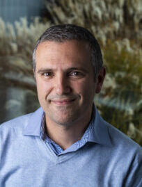
Devis Tuia
Ecole Polytechnique Fédérale de Lausanne (EPFL)
Devis Tuia is associate professor at Ecole Polytechnique Fédérale de Lausanne (EPFL, Switzerland). He received his Msc and PhD degrees from the University of Lausanne, Switzerland, with a thesis studying kernel methods for VHR remote sensing of cities. During his following postdoctoral appointments at the University of València (Spain), CU Boulder (CO) and EPFL Lausanne, he pursued research towards the integration of multiple remote sensing data sources, domain generalization and structured learning. In the period 2014-2017 he was assistant professor at the University of Zurich (Switzerland), where he led the “Multimodal remote sensing” group focused on development of machine learning strategies for fusing heterogeneous geospatial data sources. In 2017-2020, he was professor at Wageningen University, the Netherlands.
